enhancing Eleusis sacred way
Through a series of actions to be developed along the sacred route that used to connect Athens and Eleusis, this project will:
• Reinterpret the cultural landscape of the route and of the territory.
• Regenerate areas along the route creating services for the local communities and visitors.
Currently, the ancient sacred way runs through very different contexts. Starting from Athens and the Kerameikos one finds:
1. A dense urban area with some historical and archaeological heritage assets as well as some unresolved spaces that are suitable for creating sharing and resting spaces.
2. A valuable landscape characterized by the presence of the highway and of important historic and archaeological remains.
3. A stretch by the highway characterized by wide views on the sea and the lake as well as the presence of highly-impacting industrial buildings.
4. A last stretch, again urban, that crosses the town of Eleusis leading to the archaeological site.
The issues raised for the enhancement and the rediscovery of this route are therefore extremely different in nature and character.
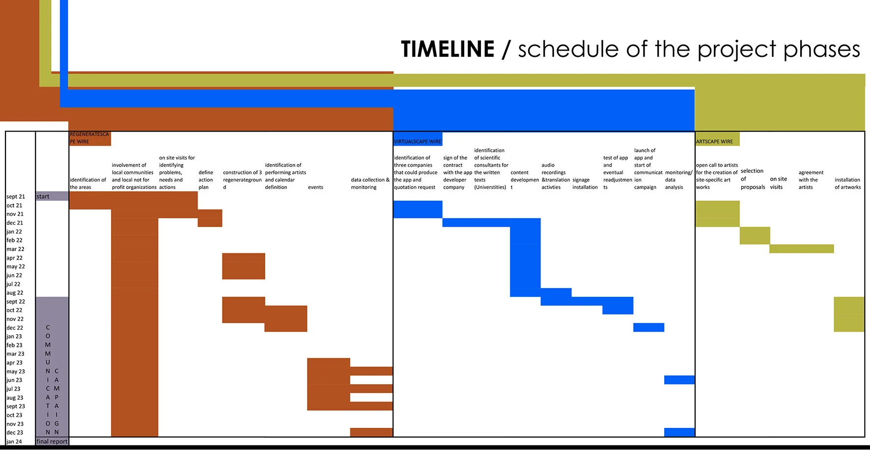
In order to re-establish the sacred route path in this current maze, we have thought of a new Ariadne’s thread, made up by three strands promoting sustainable development models based on culture, environment and society.
Along the route, the threads unroll and interweave generating a series of actions to reveal the hidden aspects of the territory and defining new interpretations and usage patterns.
The first wire is the REGENERATESCAPE WIRE. This is a material wire which unrolls along the path regenerating the contemporary city. It enters in the urban fabric regenerating the urban space, creating new public spaces with different uses and defining sharing and exchanging spaces.
How
The wire becomes carpet, playground, tent, projection screen, space for events, performances, leisure space for adults and children. It uses neglected spaces transforming them into proximity hubs thanks to the engagement of the local associations.
A reference for this activity can be the Zaragoza experience (arch. Gravalos Di Monte) through which, some empty urban spaces were reused thanks to a contract that private owners signed with the Municipality in order to freely let the space to the public authorities.
Who
Local communities
Local not for profit organizations
Local schools
Visitors
Tourists
The number of Regeneratescape activities can increase according the further funds raised through fundraising activities.
Once activated, the regeneration project of unresolved areas by the path can continue also after Eleusi Capital of Culture 2023.
The second wire is the VIRTUALSCAPEWIRE. This is a virtual wire in which information on the historic, archaeological and landscape values flow throughout 20 kilometres. The information is made accessible through an app. Those travelling on the sacred way from Athens to Eleusis, when in proximity of a historic-archaeological asset, receive a signal inviting them to stop, investigate and visit.
Who
Sustainable tourism
Local communities
The third wire is the ARTSCAPEWIRE which consists in a network of spots that are activated thanks to site specific artworks (sculpture, land art, audio artworks) of international artists coming from different cultures.
The ARTSCAPES open new visions and new landscape interpretations.
The art installations act as catalysts in the different contexts that, one after the other, make up the route. The artworks suggest new perspectives on the industrial landscape, the suburbs and the archaeological sites which, thanks to a greater participation, come back to life.
How
Through the involvement of local and international artists and their site-specific artworks revealing the most hidden places.
Some artworks will stay in situ cf. Documenta-Kassel AA, an event that has contributed significantly to the rebirth of the city
Who
Visitors
Local communities
Artists
Galleries
MOREOVER
The ideal solution would be to realize also a cycle and pedestrian protected path along the route. However, the time and budget needed for creating this type of infrastructure go beyond this bid.
Nevertheless, Eleusis European Capital of Culture can be a unique occasion for developing sustainable mobility paths, more specifically a multifunctional cycle-pedestrian path not only for tourism and recreational activities, but also for labour and school mobility.
Among other funding opportunities, we recall:
• Funding from the European Commission within the Next Unlocking EU plan and more specifically Unlocking EU Funds For Cycling Investments. A guide to 2021-2027 Programming Documents- Greece.
Other partners could include:
• Cycling Industries Europe
• European Cycling Union
• Hellenic Cycling Federation


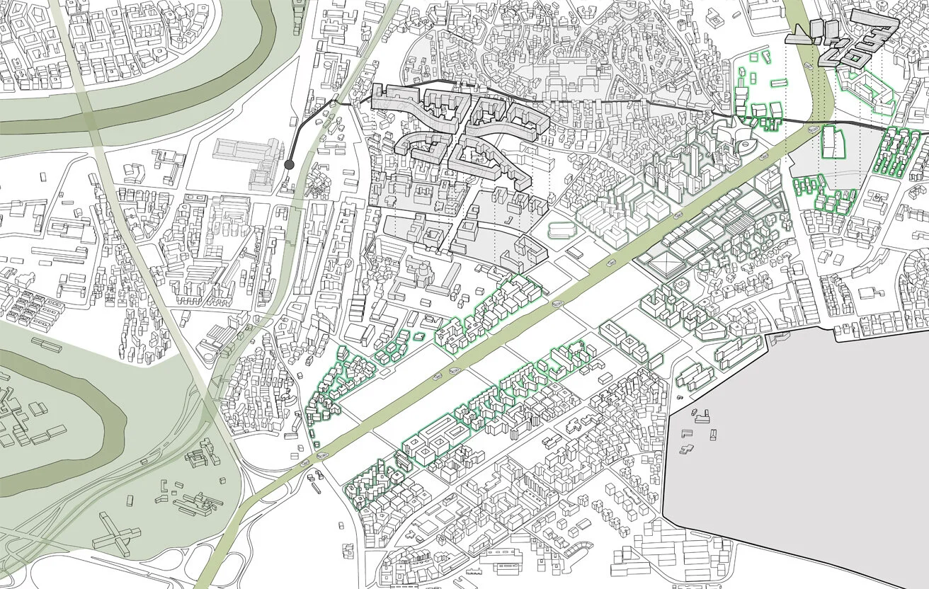
The 'META - C.COLOMBO' project is about the transformation of a section of Rome's historic avenue, from ‘Piazza dei navigatori’ to ‘Piazza del lavoro’, into a meta-circuit of transport infrastructure, greenery, energy production and sport through a series of spatial interventions that compose a utilitarian landscape circuit that occupies the field defined by its layout as it crosses the urban fabric.
C. Colombo - A monument to the car
The C. Colombo avenue is one of the most distinctive roads in the city of Rome as it connects the historical centre with the E.U.R. zone. Through a series of historical episodes, a main feature of Rome's architectural diversity, it crosses parts of the city with strongly heterogeneous characteristics while maintaining its "monumental" character, thus fracturing the urban fabric due to the incompatibility of its scale.
A 'giant' crosses the city
For 2.5 kilometers from one square to the other, the C.Colombo runs in a perfect straight line through the fabric and separates parts of the city, allowing crossing only in a few places. Along its sides and due to its enormous traffic volume, large facilities were developed at points but between them there are still gaps, small-scale buildings, as well as low-density parts of the tissue.
Historical and morphological circumstances that have led to a contemporary dynamic between urban segments.
The first tracing of C.Colombo is contemporary with the E.U.R. project. In its evolution, the layout meets the Ostienze central station, the historic district of Garbatella and crosses Via Delle Sette Chiese, before the new sections of the urban fabric around it were even developed. All along its route it moves in the area between the Tevere River and the Caffarella Park. Since its construction, various historical circumstances have created its current form.
It is worth noting that the area under study is the intersection of three (3) strategic sections of the new general plan of the city of Rome (NUOVO PRG 2000), which give the area even stronger dynamics.
In addition to the urban planning analysis to approach the issue of the street and the city as well as the relationship between them, other types of targeted analyses were carried out.
The city around the road.
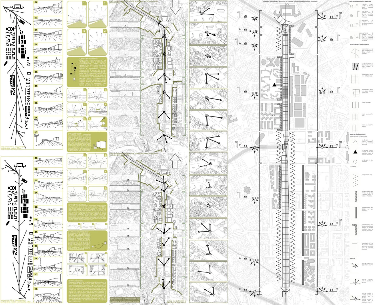
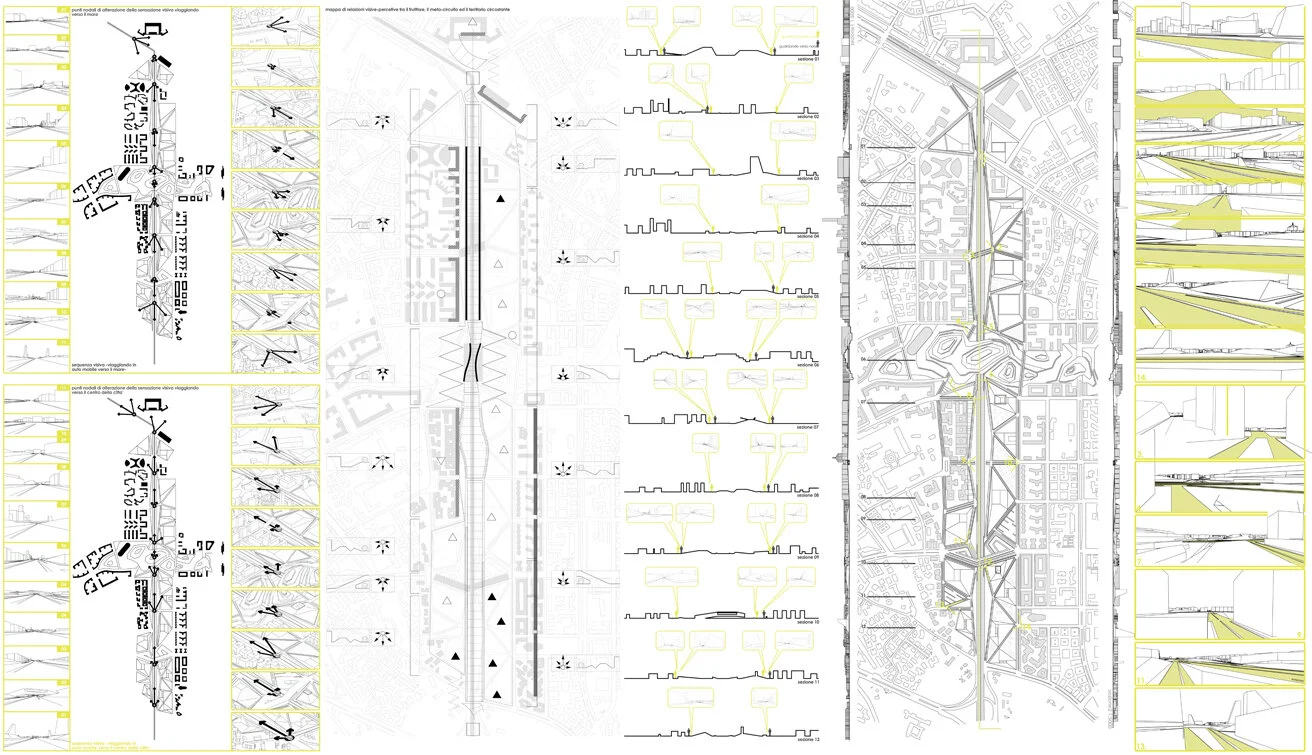
The method for C.Colombo's topological analysis is derived from K.Lynch's research on the topic of the street in his book "View From The Road". This research established the value, beyond the historical one, of the layout of the highway, through patterns that demonstrate the perception of information and the perception of space by each user-driver of a car which are summarized in a topological map. It was thus decided to maintain the historical layout and to intervene only on the 'Z' axis in order to improve the quality of the user-space relationship always through a motor vehicle.
The road through the city.
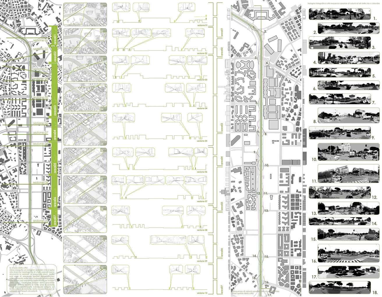
By studying the position and the relationship of the area occupied by the highway with the urban surroundings and taking into account the information of the comparative topological analysis carried out with reference to a method by S.Holl in his book "Parallax", transversal sections were created that represent the continuity of the urban fabric and demonstrate the particular discontinuity phenomena caused by the passage of the highway among them. In addition, this method also establishes the spatial relationships between the built environment, the urban voids and the C.Colombo mainly in terms of scale and the evolution of these phenomena along a longitudinal section.
By synthesizing the different types of analysis, we reach conclusions concerning the relationship between the urban fabric, the layout of the avenue and the parts under transformation around it.
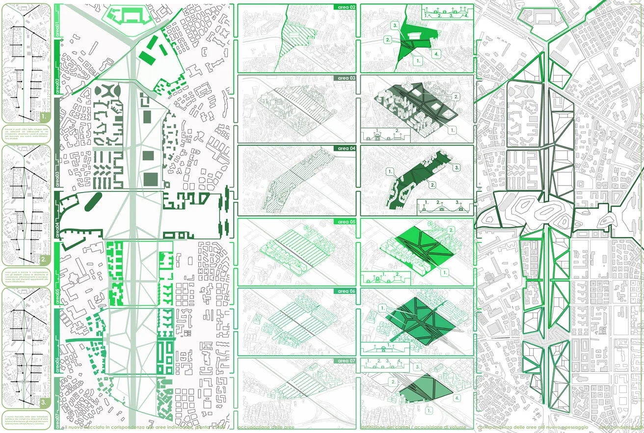
META-CRISTOFORO COLOMBO
The construction of the method
For the construction of the intervention method in the "META-C.COLOMBO" project, areas where the longitudinal sections showed particular and different unevenness were initially defined. In the area under study and in direct contact with the layout of the highway, the directions of vertical small-scale inactive crossings were determined, as well as the nodal points of discontinuity or correspondence, which together are linked in an indicative topological diagram - guide for the spatial intervention. In this way a series of tracings is formed that together with the central tracing of C.Colombo accomplish a functional network in space, to thus create a meta-circuit - landscape
The subcircuits - systems of the meta-circuit present five (5) types.
A) Energy production circuit
B) Cultural circuit consisting of a museum-theatre dipole
C) Environmental circuit
D) Sports circuit
E) Transport infrastructure circuit
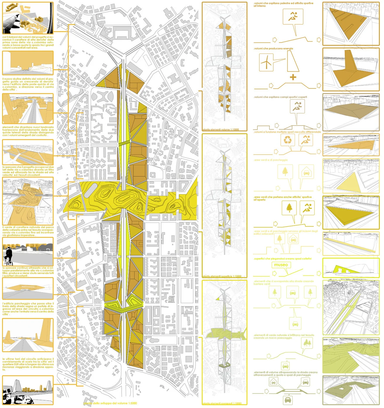
Meta-circuit C.Colombo - A dynamic continuity in a changing space
The final part of the study repeats the topological and spatial investigations considering the circuit in service. The new topological maps demonstrate the connection and functioning of the fabric on both sides of the boulevard as a unique system intertwined with C.Colombo. The avenue itself is no longer interrupted but its traffic is combined with the roadside network and becomes a pleasant experience for the user, having now acquired a relationship with the space, the landscape and the "urban objects" as they "move" around it.
The problems related to the incompatibility of scale and the heterogeneity of the fabric become an opportunity to create new urban space, new facilities, a new functional part of the city, a component in the effort to improve the living standards of citizens.

ΜΙΑ ΠΑΛΙΑ ΙΣΤΟΡΙΑ
Το γήπεδο της λεωφόρου Αλεξάνδρας πριν ακόμα αρχίσει να χρησιμοποιείται αποτέλεσε αντικείμενο έριδας και τόπο ιστορικών και πολιτικών γεγονότων της σύγχρονης Ελλάδας.
Ήταν τόπος εγκατάστασης των προσφύγων της Μικράς Ασίας και έτσι έπαιξε ρόλο στην κατασκευή της οργανωμένης δόμησης στην απέναντι πλευρά της λεωφόρου - του έργου των Λάσκαρι και Κυριάκου. Τμήμα του είχε μετατραπεί σε νοσοκομείο και ορφανοτροφείο κατά το δεύτερο παγκόσμιο πόλεμο και αργότερα είχε καταληφθεί και λεηλατήθηκε από τους στρατιώτες του άξονα. Από εκεί ξεκίνησε μια μεγάλη πορεία κατά των Γερμανών κατακτητών πριν ακόμα εγκαταλείψουν την Αθήνα και έγινε τόπος γεγονότων που σχετίζονται με τον εμφύλιο πόλεμο που ακολούθησε.
Έγινε όχημα και μάρτυρας σημαντικών γεγονότων της ελληνικής αθλητικής ιστορίας κυρίως του ποδοσφαίρου - ήταν το πρώτο γήπεδο στην Ελλάδα με κερκίδα, χλοοτάπητα, νυκτερινό φωτισμό, η πρώτη έδρα της ελληνικής εθνικής ομάδας ποδοσφαίρου όπως και ιστορική έδρα της ποδοσφαιρικής ομάδας του Παναθηναϊκού και των υπολοίπων αθλητικών τμημάτων του συλλόγου.
Φιλοξένησε επίσης ένα μεγάλο αριθμό από μουσικά πολιτιστικά γεγονότα, ορισμένα πρωτόγνωρα για τα ελληνικά δεδομένα της εποχής, όπως την συναυλία των Ρόλινγκ Στόουνς το 1967.
ΤΙ ΑΦΗΝΕΙ ΑΥΤΟ ΠΟΥ ΦΕΥΓΕΙ;
Το κτήριο αποτέλεσε όχημα της πολιτικής, αθλητικής και πολιτιστικής ιστορίας της Αθήνας για σχεδόν 100 χρόνια και δεν πρέπει να κατεδαφιστεί εξ ολοκλήρου. Προκειμένου να μη χαθεί για πάντα ένα αυθεντικό κομμάτι της ιστορίας και το πνεύμα του τόπου σωπάσει, ένα τμήμα της κατασκευής μπορεί να διατηρηθεί και να μετατραπεί σύμφωνα με το πρόγραμμα του έργου ´ Διπλή Ανάπλαση ´ σε ένα μουσείο - τόπο της μνήμης.
Η ΘΕΑ ΑΠΟ ΤΟ ΔΡΟΜΟ (VIEW FROM THE ROAD)
Το κτήριο του γηπέδου δεν πρέπει να αφαιρεθεί συνολικά από τον αστικό ιστό και για άλλους λόγους. Η λεωφόρος Αλεξάνδρας είναι ένας δρόμος της Αθήνας με σαφώς προσδιορισμένο χαρακτήρα τον οποίο οι χρήστες αντιλαμβάνονται κυρίως μέσα από κινούμενα οχήματα. Ο χαρακτήρας αυτός θα αλλοιωνόταν αν τη θέση ενός τοπόσημου του δρόμου και της πόλης έπαιρνε ένα κενό. Τέλος αν η εξέδρα της λεωφόρου Αλεξάνδρας διατηρηθεί θα λειτουργήσει ευεργετικά και για το χώρο πρασίνου - την άλλη χρήση που προβλέπει το πρόγραμμα- σχηματίζοντας έναν ηχοφράκτη που θα μετριάσει τις επιπτώσεις της έντονης κίνησης του δρόμου.
ΤΟ ΜΟΥΣΕΙΟ ΕΙΝΑΙ ΗΔΗ ΕΔΩ
Διατηρώντας το τμήμα του κτηρίου που εφάπτεται στη λεωφόρο Αλεξάνδρας και αποτελείται από 19 πλαίσια υποστυλωμάτων που στηρίζουν την εξέδρα, εκτός από ένα αυθεντικό κομμάτι της ιστορίας διατηρούμε και μια δομή ικανή να φιλοξενήσει πληθώρα χρήσεων. Η γραμμική αυτή χωρική διάταξη μπορεί να ερμηνευτεί με διαφορετικούς τρόπους και ακολουθώντας το πρόγραμμα να αποτελέσει τους κύριους χώρους του μουσείου, του εστιατορίου και του αναψυκτηρίου παράγοντας μια χωρική ακολουθία.
Ένα σκάμμα και στις δυο πλευρές της τομής της εξέδρας, δημιουργεί δύο αίθρια - ανατολικό και δυτικό- δίνει πρόσβαση στην υπόγεια στάθμη και λειτουργεί σαν ένα ανεστραμμένο βάθρο που οριοθετεί τη χωρική αλληλουχία. Αυτή συγκροτείται απο τρεις χωρικές ενότητες, δύο αποτελούν το χώρο του μουσείου ενώ η τρίτη το εστιατόριο - αναψυκτήριο. Η έκταση τους ορίζεται από στοιχεία που ήδη υπάρχουν στην παρούσα διάταξη του γηπέδου, τις τρεις θύρες επι της λεωφόρου που διαπερνούν το σώμα του, δίνοντας πρόσβαση στην εξέδρα και στον πρώην αγωνιστικό χώρο.
ΑΠΟ ΤΗΝ ΑΝΑΤΟΛΗ ΩΣ ΤΗ ΔΥΣΗ
Η διαδρομή διατρέχει το κτήριο στον άξονα Ανατολή - Δύση και ξεκινά με τα δύο πρώτα πλαίσια που μένουν κενά σχηματίζοντας το χώρο υποδοχής του μουσείου ανοικτό αλλά στεγασμένο. Εδώ οι χρήστες συναντιούνται, ενημερώνονται και προετοιμάζονται για την επίσκεψη χωρίς να είναι εκτεθειμένοι στις καιρικές συνθήκες. Ο επόμενος χώρος κάτω από την κλίμακα της θύρας 4 φιλοξενεί το εκδοτήριο και άλλες βοηθητικές χρήσεις αποτελώντας τη ζώνη - φίλτρο μεταξύ του εξωτερικού και του εκθεσιακού χώρου του μουσείου. Ακολουθούν οι δύο μεγάλες αίθουσες εκθεμάτων που χωρίζονται από τη θύρα 3 και καταλήγουν στο χώρο κάτω τη θύρα 2 φίλτρο προς την τρίτη χωρική ενότητα: το εστιατόριο - αναψυκτήριο. Το τελευταίο πλαίσιο προς το δυτικό σκάμμα μένει ξανά κενό προκειμένου να εξομαλύνει τη μετάβαση από τον εσωτερικό χώρο στο αίθριο.
Τα τρία περάσματα που δημιουργούν οι θύρες διασχίζοντας τον όγκο του κτηρίου δίνουν μια ακόμα δυνατότητα: επιτρέπουν στον περαστικό μια ‘κλεφτή´ ματιά μέσα στο χώρο του μουσείου ενθαρρύνοντας μια μελλοντική επίσκεψη. Ανάλογη ευκαιρία παρουσιάζεται και στην όψη του κτηρίου επί της λεωφόρου Αλεξάνδρας. Αν και εκεί τα ανοίγματα διευρυνθούν θα διευκολύνουν το φυσικό φωτισμό προσελκύοντας ταυτόχρονα το ενδιαφέρον των περαστικών. Ένα διάτρητο στέγαστρο παράλληλο στη λεωφόρο σχηματίζει μια στοά που θα προστατεύει τους περαστικούς από τις καιρικές συνθήκες μετατοπίζοντας ταυτόχρονα τη διαδρομή και την προσοχή τους πιο κοντά στο μουσείο.
Η ΚΕΡΚΙΔΑ ΓΕΜΙΖΕΙ ΞΑΝΑ
Η κερκίδα που παραμένει πάνω από το τμήμα του κτηρίου που διατηρείται θα αποτελέσει το βατό δώμα του μουσείου. Θα αποτελέσει όμως και το γενεσιουργό πεδίο που εξοπλισμένο με περισσότερα στοιχεία θα παραλάβει και νέες χρήσεις. Η χρήση της κερκίδας θα παραμείνει σημειακά σχηματίζοντας ένα μικρό θέατρο, ενώ οι ράμπες μεταξύ των αναβαθμών που θα διευκολύνουν την πρόσβαση μαζί με το βατό στέγαστρο-στοά επι της λεωφόρου θα συνθέσουν μια promenade architecturale. Έναν περίπατο που δίνει τη δυνατότητα στο χρήστη να αντιληφθεί το περιβάλλον συσχετίζοντας τα στοιχεία γύρω του ( τη λεωφόρο και τα μεγάλα κτήριά της, τον Λυκαβηττό, το πάρκο και τους κτηριακούς όγκους πέρα από αυτό.) Επιμήκη στέγαστρα παράλληλα στη φορά της λεωφόρου θα σκιάζουν τμήματα του περίπατου λειτουργώντας ταυτόχρονα και ως αστικά σινιάλα (4). Στους αναβαθμούς πάνω από το εστιατόριο θα προστεθούν πρίσματα (5) από σκυρόδεμα προκειμένου να χρησιμοποιηθούν σαν τραπέζια και να επεκτείνουν τη χωρητικότητά του.
ΠΟΛΛΟΙ ΤΟΠΟΙ - ΕΝΑ ΨΗΦΙΔΩΤΟ ΠΑΡΚΟ
Το πρόγραμμα του έργου ´ Διπλή Ανάπλαση ´ προβλέπει έκτος από το μουσείο, τη δημιουργία χώρου πράσινου για το υπόλοιπο της έκτασης του γηπέδου που αποσύρεται. Προκειμένου οι χρήσεις να ευδοκιμήσουν και το γήπεδο να μετατραπεί σε ένα ζωντανό κύτταρο της πόλης πρέπει να συνδεθεί με το αστικό του περιβάλλον. Προτείνεται ο χώρος πρασίνου να χωριστεί σε μικρότερες μονάδες, μικρά διαφορετικά μεταξύ τους μονοθεματικά άλση που θα αποτελούν τα στοιχεία ενός μεγάλου ψηφιδωτού. Τα άλση θα ανακαλούν αφηρημένα μνήμες των τοπίων της Αττικής. Ένας μικρός ελαιώνας, μια πυκνή συστάδα κυπαρίσσια, πεύκα, αλμυρίκια σε άμμο, λεύκες, συκιές, αμυγδαλιές, βελανιδιές, ένας μεγάλος πλάτανος, μια κληματαριά και άλλα χαρακτηριστικά φυτά και δέντρα άλλα φυλλοβόλα και άλλα αειθαλή θα αλλάζουν την δομή του χώρου στο πέρασμα των εποχών του έτους. Από ένα σχεδόν ενιαίο δροσερό στέγαστρο το καλοκαίρι σε μια ηλιόλουστη πλατεία με λίγες σκιές το χειμώνα. Τα άλση θα είναι πυκνά με ξέφωτα που θα φιλοξενούν τον εξοπλισμό κυρίως καθίσματα αλλά και βρύσες, παιχνίδια, αγάλματα.
Τα άλση χωροθετούνται σε σχέση με ήδη υπάρχοντα στοιχεία που πλαισιώνουν το γήπεδο. Άλση και παιδικές χαρές μπροστά στα σχολεία με σκοπό να χρησιμοποιηθούν από τους μαθητές, ένα μικρό υπαίθριο γυμναστήριο στην νοτιοδυτική γωνία του οικοπέδου - εκεί που θα κατέληγε ένα σύστημα πρασίνου με αφετηρία τον Λυκαβηττό, μια πέργκολα με κληματαριά απέναντι από την ιστορική ταβέρνα στην οδό Παναθηναϊκού προκειμένου και αυτή να συμμετάσχει. Οι χώροι ανάμεσα στα άλση μένουν κενοί για να σχηματίσουν μικρές και μεγάλες πλατείες που θα κατοικηθούν εκτός από τους επισκέπτες, από έργα τέχνης, εγκαταστάσεις μόνιμες ή προσωρινές, υδάτινες επιφάνειες που θα συντελέσουν στον απαραίτητο δροσισμό του χώρου. Οι επιστρωμένες επιφάνειες τους θα είναι υδατοδιαπερατές ώστε να λειτουργούν σαν ένα μεγάλο σφουγγάρι που θα αποθηκεύει το βρόχινο νερό σε υπόγειους ταμιευτήρες για να καλύπτει μέρος των αναγκών του πάρκου και του μουσείου κατά τις άνυδρες εποχές του χρόνου. Ευκαιρία αποτελούν και οι δύο υπόγειες διαβάσεις κάτω από τη λεωφόρο Αλεξάνδρας. Η πρώτη μπροστά στη θύρα 3 συνδέει το μουσείο με τα ‘προσφυγικά’ και όποια χρήση εγκατασταθεί μελλοντικά σε αυτά, ενώ η δεύτερη από το κτήριο του Αρείου Πάγου θα καταλήγει πια μέσα στο δυτικό αίθριο δίνοντας έτσι πρόσβαση στους χρήστες του συγκροτήματος των δικαστηρίων στους χώρους αναψυχής του πάρκου αλλά και στο αναψυκτήριο του μουσείου.
Η διατήρηση ενός τμήματος του γηπέδου Απόστολος Νικολαΐδης και διασκευή του σε μουσείο είναι η ευκαιρία να διαφυλάξουμε ένα αυθεντικό κομμάτι της ιστορίας, ένα όχημα γεμάτο με τις αναμνήσεις της πόλης που σχετίζονται με σημαντικά γεγονότα των τελευταίων εκατό ετών και να του δώσουμε νέα πνοή. Είναι η ευκαιρία χωρίς να αλλοιώσουμε τον αστικό χαρακτήρα να εγκαταστήσουμε ένα νέο χώρο πράσινου -μακάρι μέρος ενός ευρύτερου συστήματος- ένα χώρο μνήμης και πολιτισμού.
Είναι η ευκαιρία αυτό που φεύγει να αφήσει ένα νέο δοχείο ζωής.
This stadium (early 20th century) located within the urban tissue of the city of Athens will soon be demolished and replaced by a park and a small museum.
But perhaps the museum is already there.
What if, instead of demolishing the entire stadium, part of the structure was retained, where it would make more sense, to create a shell to host the museum?
AN OLD STORY
The stadium of Alexandras Avenue was, even before it started to be used, an object of controversy and a place of historical and political events in modern Greece.
It was the first place of settlement for refugees from Asia Minor and thus played a decisive role in the construction of the public housing project on the opposite side of the avenue. Part of it was converted into a hospital during the Second World War and later occupied and looted by Axis soldiers. From there a great march against the German occupation forces began and later on it became the scene of events related to the civil war that followed.
The building became a vehicle and witness to important events in Greek sporting history, especially football - it was the first stadium in Greece with a grandstand, turf, night lighting, the first home of the Greek national football team, as well as the historic home of the Panathinaikos football team and the other sports sections of the club.
It also hosted a large number of musical and cultural events, some of them unprecedented for the Greek standards of the time, such as the Rolling Stones concert in 1967.
WHAT IS LEFT BEHIND BY WHAT IS GONE
The building has been a vehicle of Athens' political, sporting and cultural history for almost 100 years and should not be demolished in its entirety. In order to prevent an authentic piece of history from being lost forever and the spirit of the place from being silenced, a part of the structure can be preserved and transformed according to the programe of the ´Διπλή Ανάπλαση´ project into a museum - a place of memory.
VIEW FROM THE ROAD
The stadium building should not be removed from the urban fabric altogether for other reasons too. Alexandras Avenue is a street in Athens with a clearly defined character which users perceive mainly through moving vehicles. This character would be altered if a landmark is replaced by a void. Lastly, if the Alexandras Avenue grandstand is retained, it will also be beneficial to the green space - the other use envisaged by the project - by forming a sound barrier that will mitigate the effects of heavy traffic on the road.
THE MUSEUM IS ALREADY HERE
By preserving the part of the building that is adjacent to Alexandras Avenue and consists of 19 frames of columns that support the platform, apart from an authentic piece of history, we are preserving a structure capable of accommodating a variety of uses. This linear spatial arrangement can be interpreted in different ways and following the program can be the main spaces of the museum, restaurant and cafe’ area, producing a spatial sequence.
A trench on both sides of the grandstand section creates two atriums - east and west; it gives access to the underground level and acts as an inverted pedestal that delineates the spatial sequence. This is made up of three spatial units, two of which are the museum space and the third is the restaurant-cafe’. Their area is defined by elements that already exist in the current layout of the stadium, the three gates on the avenue that run through the body of the building, giving access to the stand and the former pitch. The route runs through the building on the east-west axis and begins with the first two panels left empty, forming the reception area of the museum open but covered. Here users meet, are informed and prepare for the visit without being exposed to the weather. The next space below the door scale houses the ticket office and other ancillary uses, forming the filter zone between the outdoor area and the museum's exhibition space. Next are the two large exhibit halls separated by gate 3 and ending in the space below gate 2 filter to the third spatial unit: the restaurant - cafe’. The last frame towards the west trench is again left empty in order to moderate the transition from the interior space to the atrium.
The three passages created by the stadium gates crossing the volume of the building provide another possibility: they allow the passer-by a 'sneak' peek into the museum space encouraging a future visit. A similar opportunity is presented on the facede of the building on Alexandras Avenue. The openings there are widened, to facilitate natural lighting while attracting the interest of passers-by. A perforated sunshade parallel to the avenue forms a portico that will protect passers-by from the weather while shifting their route and attention closer to the museum.
THE GRANDSTAND FILLS UP AGAIN
The grandstand that remains above the part of the building that is preserved will form the museum's walkable roof. But it will also be the generative field that, equipped with more elements, will receive new uses. The use of the grandstand will remain, forming a small theatre, while the ramps between the terraces that will facilitate access, together with the walkable shadeover the avenue, will compose a promenade architecturale. A promenade that enables the user to perceive the environment by relating the elements around him ( the avenue and its large buildings, Lycabettus hill, the park and the buildings beyond). Elongated sunshades parallel to the direction of the avenue will shade parts of the promenade, acting at the same time as urban signals. Concrete prisms will be added to the terraces above the restaurant to be used as tables and extend its capacity.
MANY PLACES - ONE MOSAIC PARK
The ´Διπλή Ανάπλαση´ project programe envisages, in addition to the museum, the creation of green areas for the rest of the surface of the retiring stadium. In order for the uses to flourish and for the stadium to become a living cell of the city, it must be linked to its urban environment. It is proposed to divide the green area into smaller units, instead of a single park, small different groves that will form the elements of a large mosaic. The groves will recall abstract memories of the landscapes of Attica. A small olive grove, a dense cluster of cypresses, pines, sand tamarisk, poplars, fig trees, almond trees, oaks, a large plane tree, an arbor and other characteristic plants and trees, some deciduous and others evergreen, will change the structure of the space through the seasons of the year. From an almost single shelter in summer to a sunny square with some shade in winter.
The groves will be dense with clearings that will accommodate equipment mostly seating but also fountains, games, statues, perhaps even a small temple. The groves are sited in relation to existing elements that surround the stadium. Groves and playgrounds in front of the schools in order to be used by the students, a small outdoor gym in the southwest corner of the site - where a green system starting from Lycabettus hill would end, a pergola with an arbor opposite the historic tavern on Panathinaikos Street in order to involve it as well. The spaces between the groves are left empty to form small and large squares that will be inhabited not only by visitors, but also by works of art, by permanent or temporary installations, by water surfaces that will contribute to the necessary cooling of the space. Their paved surfaces will be water-permeable to act as a large sponge that will store rainwater in underground reservoirs to meet part of the needs of the park and the museum during the dry seasons.
The two underground crossings of Alexandras Avenue are also an opportunity. The first in front of Gate 3 connects the museum to the the public housing project and any future use that will be installed in it, and the second from the Supreme Court building will now end in the western atrium giving users of the court complex access to the park's recreational areas and the museum's cafe’.
The preservation of a part of the Apostolos Nikolaidis stadium and its adaptation into a museum is an opportunity to maintain an authentic piece of history, a vehicle filled with the memories of the city related to important events of the last hundred years and to give it new life. Without altering its urban character to install new green spaces -part of a larger system- together with spaces of memory and culture.